Rosor Exploration

Choosing a provider

Any drone can carry a magnetometer. Choosing the provider is where programs are won.

These are the questions to ask any bidder, and we mean any. Run every proposal through the list before you sign, ours included.

Seven questions decide whether you get a dataset you can drill on or a folder of grids nobody opens.

Four of them settle the data itself. Three settle whether that data reaches your team in a form it can use.

The data questions

What should you ask before awarding a drone survey?

Four questions separate a dataset you can drill on from a folder of grids nobody opens. Ask them of every bidder and compare the answers side by side.

  1. 01

    Quality control on site

    Ask when the data actually gets looked at: before the crew leaves the ground, or weeks later on a processing bench. A bad line discovered on the bench leaves a gap in your dataset, and closing that gap means a second mobilization. We review the data-quality metrics daily and adjust acquisition while the survey is underway, so a problem is dealt with in the same conditions rather than on the bench weeks later.

  2. 02

    Loaded flight times

    Ask whether the quoted flight times were flown with the sensor payload aboard. Spec sheets built on stripped-down rigs inflate daily coverage, so a schedule and a budget built on empty-rig endurance will not survive contact with your survey. Our numbers are the loaded numbers, flown with the full sensor payload, Starlink and D-GPS. Ask every bidder to confirm the same in writing.

  3. 03

    Complete flight geometry

    Ask whether the flight plan still carries the cross-check geometry that processing needs. Processing can only verify and level a dataset when those cross-check lines are in the plan, and trimming them cuts line-kilometres and the bid price together. If one bid comes in lower, ask what its flight plan leaves out.

  4. 04

    Interpretation-ready, with interpretation available

    Ask exactly what ships in the base scope. Every Rosor program ships interpretation-ready: raw data cleaned and leveled, map layers and an unconstrained VOXI model that integrates into your project. Geophysical interpretation with geological context is scoped, signed by geoscientists and worked through with your team.

The program questions

What should you ask about how the program runs?

Three more questions decide whether the survey informs the next hole or waits in a folder. They cover the paperwork, the field rhythm and the file formats.

  1. 01

    A proposal you can read

    Ask whether you can tell what is included. A vague scope is where back-end build-up hides, and mobilization surprises, data fees and per-deliverable charges all arrive after the award. Our proposals state what is flown, what is processed, what is delivered and what it costs, so you can set them beside any other bid.

  2. 02

    Cadence through week three

    Ask what the field rhythm looks like after the first fortnight. A crew that goes quiet or leaves for a bigger job stalls your drills, your permits and your season. You get twice-weekly progress updates and coverage maps through acquisition. Rosor crews fly up to 500 line-km of magnetics a day with multi-drone surveys on open ground within reach of roads, and less where terrain or access is harder. Deliverables arrive within an average of 15 business days of completion.

  3. 03

    Deliverable formats

    Ask what the files load into. Data your team cannot drop into its modelling environment costs days of translation, and some of it never gets opened. Rosor delivers files that open in Leapfrog, QGIS and ArcGIS, including DXF and isosurfaces, geotiffs that go into your existing datasets and raw data on request, plus an interpretive report and a findings presentation.

Loaded numbers

Ask for the loaded numbers

Every bid should state its flight time with the survey payload aboard and its positioning chain.

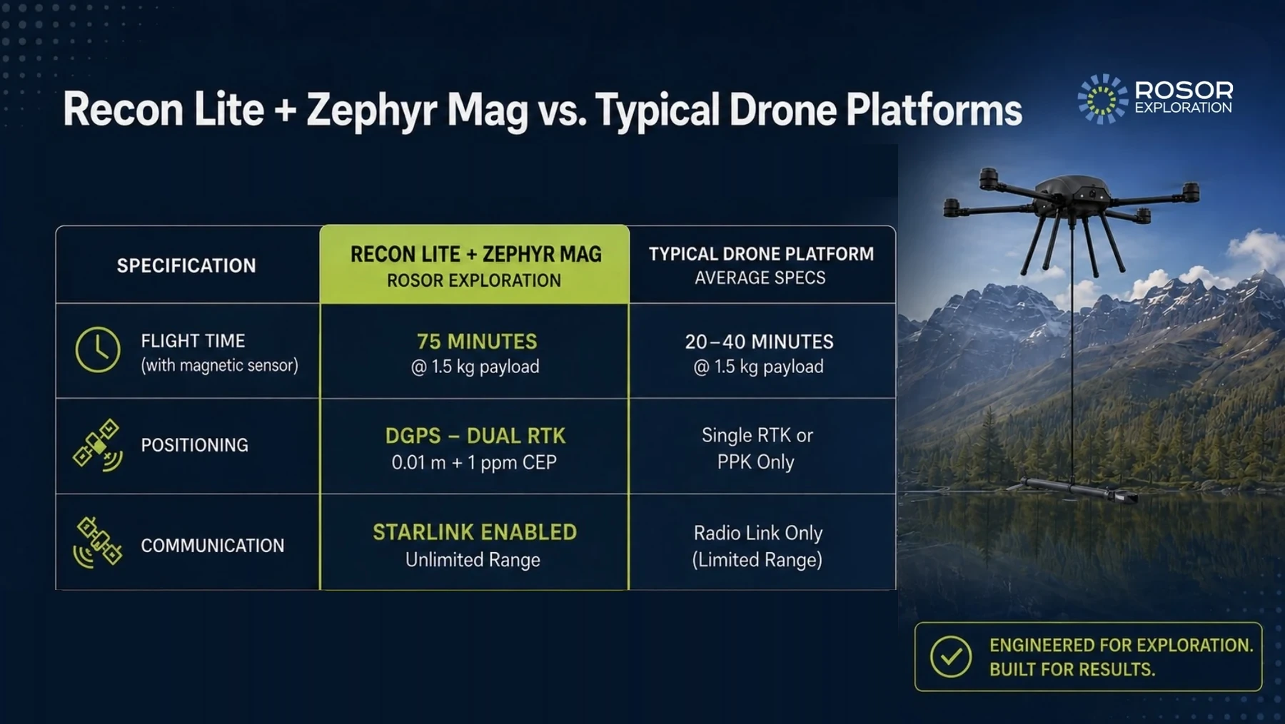
Here is one of ours against typical drone platforms, average specs: the Recon Lite carrying the Zephyr Mag gives 75 minutes at a 1.5 kg payload, differential GPS (DGPS) with dual real-time kinematic (RTK) positioning at 0.01 m + 1 ppm circular error probable (CEP), and Starlink-enabled telemetry without range limits. Electromagnetic and radiometric payloads are heavier and fly on different platforms, so their loaded numbers are quoted for your program rather than borrowed from this one.

Specification card comparing the Rosor Recon Lite with Zephyr Mag against typical drone platforms on flight time, positioning and communication
Recon Lite + Zephyr Mag against typical drone platforms, average specs.
The full Zephyr Mag spec →

Reading the bids

Why do two bids for the same ground differ so much?

A low bid comes from one of two places. One provider flies more line-kilometres a day with the full payload aboard. The other trims the flight geometry, the quality control and the interpretation. These are the line items to check on any bid, ours included. A magnetics and LiDAR program is about 6.7% of a drilling budget, closer to 15% with EM in scope. At $300 per all-in drilled metre a single 150 m hole spends $45,000, so the gap between two bids is small money next to the metres the survey aims.

  1. 01

    Quality control

    Ask when the data gets reviewed. On a Rosor program the data-quality metrics are reviewed daily and acquisition is adjusted while the crew is still on the block.

  2. 02

    Quoted flight times

    Ask whether the quoted times were flown with the full sensor payload aboard. Ours are. Times flown on a stripped-down rig overstate daily coverage, and the schedule slips to match.

  3. 03

    Flight plan

    Ask whether the plan keeps its cross-check geometry. Ours does, because that is what lets processing verify and level the dataset. Trimming it cuts line-kilometres and checks together.

  4. 04

    Interpretation

    Ask whether it is included and who signs it. On our programs geoscientists sign the drill-target recommendations, rather than the work arriving as an extra line item for your team.

  5. 05

    Scope

    Ask for it priced end to end, so you can set any two proposals side by side without fees and charges arriving after the award.

  6. 06

    Deliverables

    Ask what formats land. Ours open in Leapfrog, QGIS and ArcGIS: DXF, isosurfaces and geotiffs that go into your project rather than needing days of conversion.

References

Ask for references, then check ours

Every bidder should be able to put you in front of geologists who drilled on their data. These programs are published with the numbers and the client's own words, and you can ask about them.

Drone magnetics
New Found Gold — Gull River survey figure

Gull River

Grand Falls-Windsor, Newfoundland

New Found Gold
315
line-km/day on this program
~4,000
line-km completed

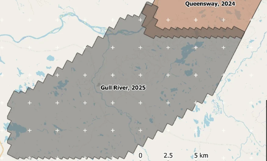
Almost 4,000 line-kilometres acquired across the program, completed on schedule despite delays from a wildfire evacuation interrupting it and geomagnetic storms. Sustained production without trading away data quality.

“The drone magnetic survey provided high-resolution structural insights that significantly improved our understanding of the subsurface geology, allowing us to refine our exploration targets.”

David Drover · Project Geologist

Read the Case Study →

Drone magnetics
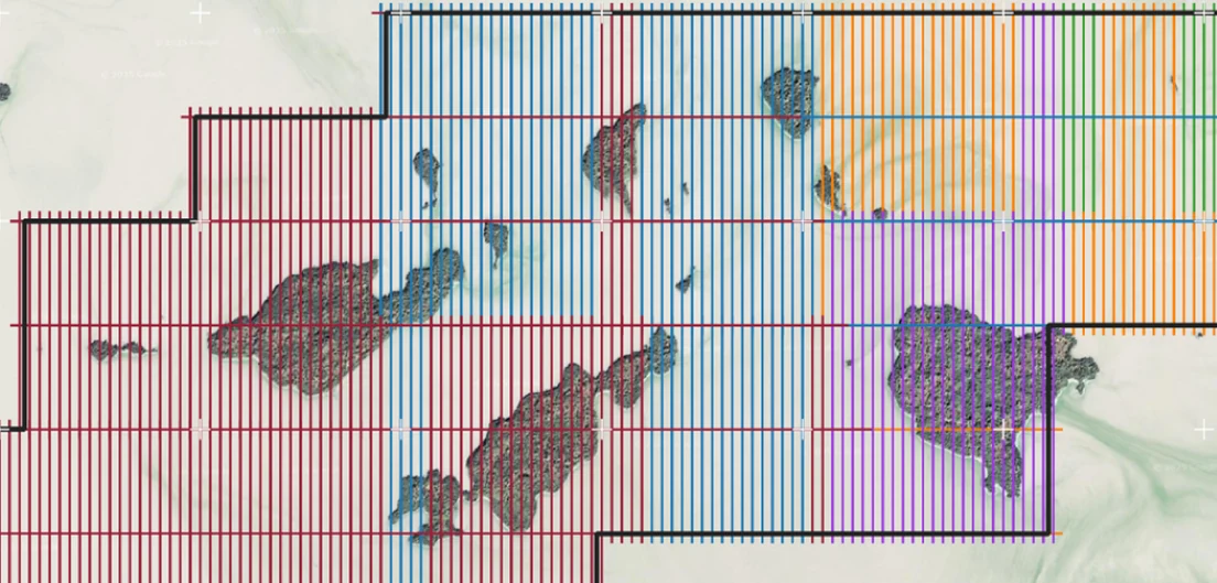
International Explorers & Prospectors — Abitibi Lake survey figure

Abitibi Lake

Abitibi Lake, Ontario, Canada

International Explorers & Prospectors
10
days, site to deliverables
3
days of acquisition

Mobilization to final deliverables in ten days, with acquisition complete in three and no mechanical downtime.

“Throughout the duration of the project, Rosor maintained clear and efficient communication with our team. They demonstrated a strong commitment to meeting deadlines by processing the collected data within a very tight time-frame, ensuring that our exploration schedule remained on track.”

Peter Colbert · CFO

Read the Case Study →

FAQ

Straight answers

01

Why do drone survey bids differ so much?

Because the scopes differ, not only the prices. Bids diverge on flight-plan completeness, on when quality control happens, on site or weeks afterwards, on whether interpretation is included and on whether the quoted flight times assume a loaded rig. Two bids that look far apart on price are often bidding different surveys, so line up the scopes before you compare the numbers.

02

What should be in the contract rather than a verbal promise?

Anything that decides data quality belongs in writing. That covers the flight-plan geometry and line spacing, the on-site quality control and re-fly commitments, the deliverable formats, the update cadence and what interpretation includes. If a bidder offers something verbally and resists writing it down, treat that as your answer.

03

How do I compare data quality claims between providers?

Ask each one to show the mechanism behind the claim. Every provider asserts high-quality data, so the adjective settles nothing. Ask how they catch a bad line before demobilization, how they handle solar interference mid-survey and what the quality-control record looks like when it arrives with the dataset. A provider with a real mechanism answers in specifics.

Talk to an expert

Send us the ground, and bring the checklist.

A shapefile and a target model are enough. We'll come back with a coverage plan and a budget range, and we'll answer every question on this page in writing.

Send us your shapefile. We'll come back with a preliminary read, a coverage plan and a budget range.