Rosor Exploration

Method comparison

Drone or helicopter? Your program decides.

Neither method is right for every program. Program size and target depth decide it, and we give you the honest read even when it points away from us.

Drone surveys suit focused programs where near-surface resolution decides the next hole.

Semi-airborne EM maps conductors and resistivity contrasts from surface down to 1000 m in the same mobilization. Regional-scale coverage is conventional airborne work. Here is how to tell which one your program needs.

Where drones win

When does a drone survey win?

Drone surveys provide an advantage over helicopters by flying closer to the ground with tighter line spacing, delivering higher-resolution data for more precise drill targeting.

  1. 01

    Resolution where it counts

    We fly a true 1:1 terrain drape at 5–100 m above ground; heliborne and fixed-wing systems fly a smoother 2D drape over the same ground. Magnetic signal falls off fast with distance from source, so holding clearance over every ridge and gully, rather than over the average of them, is what resolves the subtle anomalies, structural corridors and lithological contacts that drill targeting depends on.

  2. 02

    Speed to mobilize at focused scale

    A helicopter program carries ferry costs, fuel logistics and crew standby that only amortize over big blocks. At claim-block scale, a drone crew mobilizes on a contract and works from a truck. Crews fly up to 500 line-km of magnetics a day with multi-drone surveys on open ground within reach of roads, and less where terrain or access is harder. Deliverables arrive within an average of 15 business days of completion.

  3. 03

    Access ground crews can't safely reach

    Steep slopes, swamp, dense bush and cliff faces stop a ground crew. A drone flies the lines a crew can't walk and a helicopter can't safely follow, and terrain-following holds clearance tight even where the topography is hostile.

  4. 04

    No crew-safety exposure

    Low-level manned flight over rough terrain is one of the higher-risk activities in exploration. A drone survey takes people out of the aircraft entirely. Nobody is in the air, and the pilots work from the ground.

The mechanism

Why does flying lower change the data?

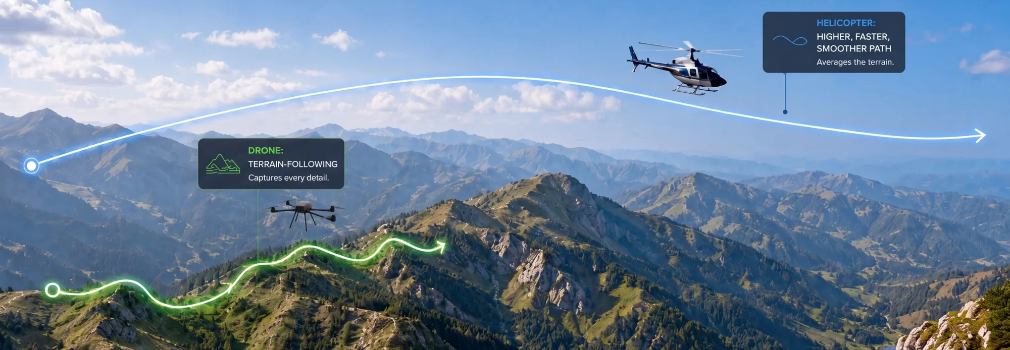
A drone follows the terrain at 5–100 m, so the sensor holds its distance from source over every ridge and gully. A helicopter flies a higher, faster, smoother path that averages the terrain beneath it.

Magnetic signal falls off steeply with distance, so holding clearance tight is what keeps anomalies sharp. The same low, slow profile also shrinks the operation's footprint. There are fewer overflights, a lower noise footprint for wildlife and nearby communities and less fuel burned per line-km.

Diagram comparing a drone's terrain-following flight path at low level with a helicopter's higher, smoother arc over the same mountains
Terrain-following at 5–100 m captures what a high, fast pass averages away.

Decision framework

Which method does your program need?

Total area and target depth settle most programs. Find the row that matches yours. The verdict is the one we would give you on a call, including where the work isn't ours and where the answer depends on your target.

The recommended method changes with program size and target depth.

Focused block (< ~100 km²)

Drone survey
RecommendedA drone resolves detail at claim-block scale, mobilizes quickly on a signed contract and keeps everyone out of the aircraft.
Conventional airborne
Built for bigger groundFerry costs, fuel logistics and crew standby only amortize over large blocks.

Mid-size program (~100–300 km²)

Drone survey
DefensibleTerrain, access and the resolution your targets need decide it.
Conventional airborne
DefensibleAt this scale the target model breaks the tie. Ask us and we'll give the straight read.

Regional program

Drone survey
Talk to us firstRosor has completed programs above 200 km², and Starlink-enabled beyond-visual-line-of-sight (BVLOS) flight keeps pushing that size upward.
Conventional airborne
Often the callAt true regional scale, conventional airborne still wins on economics and coverage.

Conductor within 1000 m, focused block

Drone survey
RecommendedSemi-airborne EM maps conductors and resistivity contrasts from surface down to 1000 m, in the same mobilization as the magnetics.
Conventional airborne
DefensibleWorth weighing when the block sits inside a larger regional airborne program.

EM target below 1000 m

Drone survey
Past our rangeSemi-airborne EM maps conductors and resistivity contrasts from surface down to 1000 m, and your target sits below that.
Conventional airborne
Depends on the targetDepth, not coverage, decides this row. We'll tell you which method fits your target.

After the method

What separates one provider from another?

Once the method is settled, the questions that matter are about the provider: how the data is checked, how honest the specs are and what you actually receive.

  1. 01

    On-site QC

    Ask when the data gets reviewed, and whether acquisition can be adjusted before the crew leaves.

  2. 02

    Full-payload honest specs

    Ask whether the quoted flight times come from a stripped rig or the loaded configuration that actually flies your survey. Our numbers are the loaded numbers.

  3. 03

    Interpretation-ready, with interpretation available

    Ask what actually ships. Our deliverables land as DXF, isosurfaces and geotiffs that open in Leapfrog, QGIS and ArcGIS, interpretation-ready on arrival, and geophysical interpretation with geological context is available scoped to the program.

Proof

What drone-scale programs look like in practice

Two programs from the case library carry the point. One shows production rate under pressure, and the other shows how fast a site visit turns into deliverables.

Drone magnetics
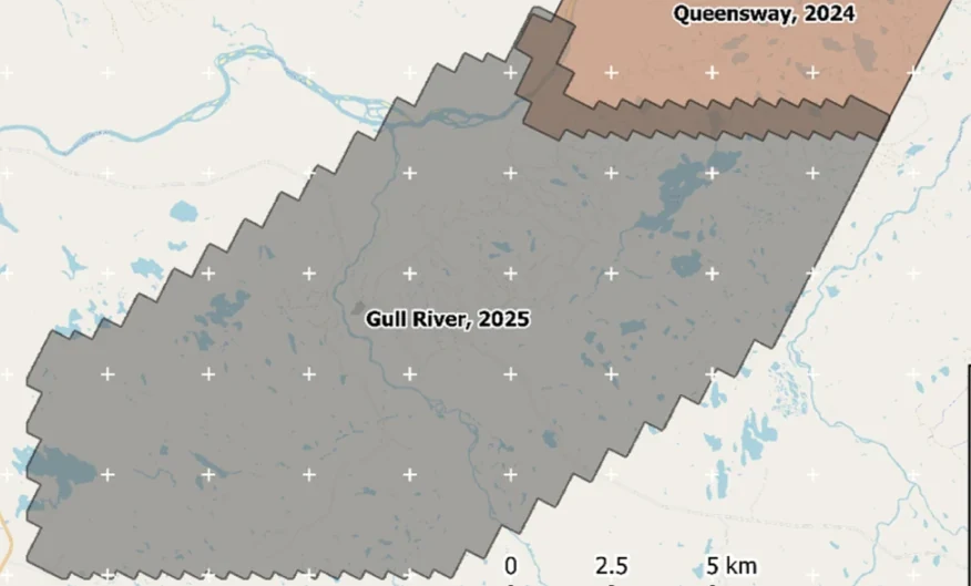
New Found Gold — Gull River survey figure

Gull River

Grand Falls-Windsor, Newfoundland

New Found Gold
315
line-km/day on this program
~4,000
line-km completed

Almost 4,000 line-kilometres acquired across the program, completed on schedule despite delays from a wildfire evacuation interrupting it and geomagnetic storms. Sustained production without trading away data quality.

“The drone magnetic survey provided high-resolution structural insights that significantly improved our understanding of the subsurface geology, allowing us to refine our exploration targets.”

David Drover · Project Geologist

Read the Case Study →

Drone magnetics
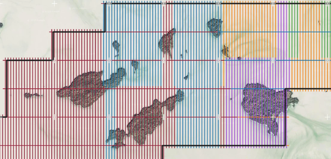
International Explorers & Prospectors — Abitibi Lake survey figure

Abitibi Lake

Abitibi Lake, Ontario, Canada

International Explorers & Prospectors
10
days, site to deliverables
3
days of acquisition

Mobilization to final deliverables in ten days, with acquisition complete in three and no mechanical downtime.

“Throughout the duration of the project, Rosor maintained clear and efficient communication with our team. They demonstrated a strong commitment to meeting deadlines by processing the collected data within a very tight time-frame, ensuring that our exploration schedule remained on track.”

Peter Colbert · CFO

Read the Case Study →

FAQ

Straight answers

01

Is drone data as good as helicopter data?

For near-surface magnetics it resolves finer detail, and the physics does the work. We fly a true 1:1 terrain drape at 5–100 m AGL, where heliborne and fixed-wing systems fly a smoother 2D drape. Magnetic signal strength falls off steeply with distance, so a sensor that holds its clearance over every ridge and gully returns a sharper anomaly than one that averages them out.

02

What happens on really steep terrain?

Steep terrain is where drones separate from both alternatives. A terrain-following drone holds tight clearance up slopes a helicopter can't safely follow and a ground crew can't safely walk. If conditions turn, nobody is in the aircraft.

03

Can you mix methods on one program?

Yes, and it's often the right answer. Fly the regional first pass with conventional airborne, then bring a drone crew for high-resolution infill over the anomalies worth drilling. The same pattern works for EM: a regional airborne pass narrows the ground, and semi-airborne EM then maps conductors across the prospect. Each method does what it does well, and the datasets merge into one working picture.

04

Which method is safer?

Drone surveys remove the crew from the air entirely. Low-level manned flight over rough terrain carries real risk, and with a drone the pilots stay on the ground. The only thing exposed to the terrain is the aircraft.

Talk to an expert

Tell us the area and the target depth.

Send a shapefile and your target model. We'll come back with the method we'd fly, a coverage plan and a budget range, even when the answer is conventional airborne.

Send us your shapefile. We'll come back with a preliminary read, a coverage plan and a budget range.