Rosor Exploration

Drone or ground crew

Drone or ground crew? Coverage, access and what your target needs.

There's no universal answer. There is a right answer for your target, your terrain and your timeline, and here's the honest per-scenario read.

A drone flies in a day the line-km a ground crew walks in weeks, and it covers ground no crew should be walking.

Tight detail grids and chargeability work still belong to a ground crew, and we say so. Most programs end up using both.

Where drones win

Where does a drone survey beat a ground crew?

A drone survey wins on coverage, access, safety and consistency. It flies in a day the line-km a ground mag crew walks in weeks, and it covers ground no crew should be walking.

  1. 01

    Coverage per day

    A ground mag crew walks its grid one station at a time. Our drone crews fly up to 500 line-km of magnetics a day with multi-drone surveys on open ground within reach of roads, and less where terrain or access is harder. A block that would tie up a walking crew for weeks is flown, checked and banked in days, which matters when the season is short and the drills are waiting.

  2. 02

    Terrain access

    Swamp, dense bush, cliff faces and talus slopes stop a walking crew. None of them stop a drone. There are no cut lines to brush out first, and the survey flies the plan as designed, straight over whatever the property throws at it.

  3. 03

    Crew safety

    Nobody walks grids in bear country, over unstable ground, or across open water. The pilot and crew stay at a safe launch point while the sensor covers the block. The risk register for a drone program is a fraction of a walking program's.

  4. 04

    Consistency

    The drone holds constant terrain clearance line after line, at 5–100 m above ground. There is no operator fatigue at hour six and no drift in station spacing at the far end of the grid. Every line is acquired the same way the first one was, and the same-day review on site is what proves it.

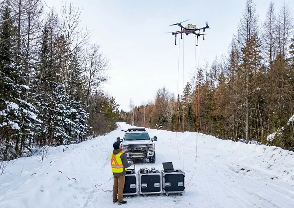
A Rosor Recon Super in flight above a snow-covered access line, with a single operator monitoring the survey from a laptop and equipment cases on the ground
Rosor Recon Super in flight, monitored from the ground on a winter access line.

Per scenario

Which one does your program need?

Find the row that matches the work in front of you. Each verdict is the one we would give you on a call, including the rows where the job belongs to a ground crew.

Each row carries the method we would recommend, and some of those rows belong to a ground crew.

Property-scale coverage

Drone survey
RecommendedDrone crews fly up to 500 line-km of magnetics a day with multi-drone surveys on open ground, so a block that takes weeks on foot is flown and checked in days.
Ground crew
Weeks on footA walking magnetometer crew covers its grid one station at a time.

Swamp, bush, cliffs, talus

Drone survey
RecommendedTerrain-following flight holds clearance over ground a crew can't safely walk, and nothing has to be cut first.
Ground crew
Access decides itLine cutting, bush travel and unstable ground add weeks before the first reading is taken.

Detail grid at very tight spacing

Drone survey
Not the callA flight plan sensibly flies wider than a grid measured in metres needs.
Ground crew
RecommendedA walking magnetometer puts stations tighter than any flight plan on a small footprint.

An IP or MT program

Drone survey
We don't offer itSemi-airborne EM maps resistivity from surface down to 1000 m and does not measure chargeability. If the real question is where conductors sit, see Conductors and resistivity at depth.
Ground crew
RecommendedA ground IP or MT crew is the right call here, and we'll point you to trusted partners.

Conductors and resistivity at depth

Drone survey
Semi-airborne electromagnetics (SAEM)The transmitter is installed on the ground while the receiver flies on the drone, mapping conductors and resistivity contrasts across a property from surface down to 1000 m without a walked receiver grid.
Ground crew
Follow-up on a known conductorGround EM can still be the right call for detailed work on a single conductor once the property has been mapped.

The hybrid pattern

Drone first, ground where the data points

For most programs the question isn't drone or ground. Strong programs fly the drone first, then send a ground crew to exactly the places the anomalies justify.

  1. 01

    Fly the property

    Drone mag covers the full block in days rather than weeks, and every magnetics line is quality-checked on site. Structural corridors, lithological contacts and the anomalies worth a closer look come out of one pass, along strike and at depth. Where conductors are the question, semi-airborne EM joins the same mobilization.

  2. 02

    Read the anomalies

    Your geologists work the grid with us and rank what the data actually supports. The priority anomalies get picked before anyone commits a crew day to the ground.

  3. 03

    Ground the follow-up

    Detail grids, ground EM on a known conductor or chargeability work go only to the areas the data earned. Crew days are the slow, weather-exposed part of a program, and this pattern spends them where the data points instead of walking the whole grid on spec.

Proof

What that pace looks like on real programs

Coverage claims are easy to make. These two programs show what the pace looked like in the field, in the clients' own words.

Drone magnetics
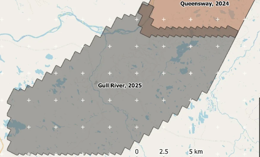
New Found Gold — Gull River survey figure

Gull River

Grand Falls-Windsor, Newfoundland

New Found Gold
315
line-km/day on this program
~4,000
line-km completed

Almost 4,000 line-kilometres acquired across the program, completed on schedule despite delays from a wildfire evacuation interrupting it and geomagnetic storms. Sustained production without trading away data quality.

“The drone magnetic survey provided high-resolution structural insights that significantly improved our understanding of the subsurface geology, allowing us to refine our exploration targets.”

David Drover · Project Geologist

Read the Case Study →

Drone magnetics
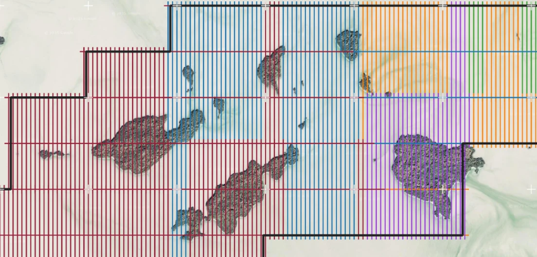
International Explorers & Prospectors — Abitibi Lake survey figure

Abitibi Lake

Abitibi Lake, Ontario, Canada

International Explorers & Prospectors
10
days, site to deliverables
3
days of acquisition

Mobilization to final deliverables in ten days, with acquisition complete in three and no mechanical downtime.

“Throughout the duration of the project, Rosor maintained clear and efficient communication with our team. They demonstrated a strong commitment to meeting deadlines by processing the collected data within a very tight time-frame, ensuring that our exploration schedule remained on track.”

Peter Colbert · CFO

Read the Case Study →

FAQ

Straight answers

01

Is drone magnetics as sensitive as ground magnetics?

For target generation, yes, and the dataset is often the better one. We fly terrain-following at 5–100 m above ground with dense along-line sampling, close enough to resolve the structures that matter, and every line is acquired at constant clearance with on-site quality control. A walking crew can put stations tighter on a small detail grid, but across a property the consistent low-level coverage wins.

02

Do we still need to cut lines?

No. Cut lines exist so walking crews can move through bush in straight lines, and a drone doesn't need them. That removes the cutting cost, the permitting and disturbance conversation and weeks from the schedule before a single reading is taken.

03

Can you fly IP?

No. We don't offer induced polarization (IP) or magnetotellurics (MT). Our frequency-domain semi-airborne EM reads resistivity at depth, from surface down to 1000 m, which is often what an IP request is really after. It does not measure chargeability, so if your target genuinely needs it, we'll say so and point you to trusted partners.

04

How do the costs compare?

Think in coverage per field day rather than day rates. A drone magnetics program covers hundreds of line-km a day with a small crew and no line cutting, so the property-scale picture arrives in days instead of weeks. A magnetics and LiDAR program typically runs about 6.7% of a drilling budget. With EM in scope it runs closer to 15%, and we'll run your program's numbers in the consult.

Talk to an expert

Send us the block and the target.

A shapefile and a target model are enough. We'll come back with a coverage plan, a budget range and a straight answer if a ground crew would serve you better.

Send us your shapefile. We'll come back with a preliminary read, a coverage plan and a budget range.