Rosor Exploration
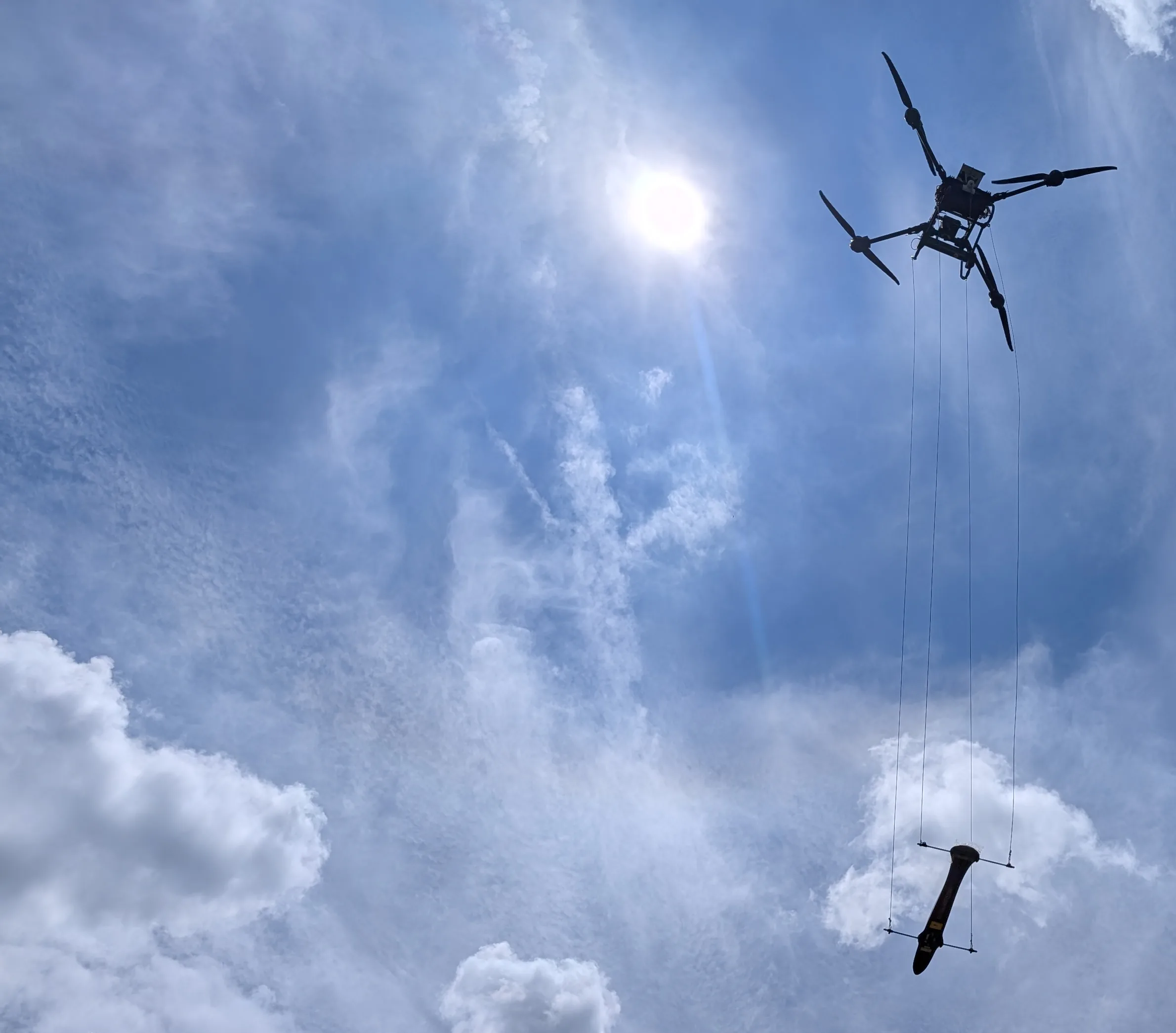
Rosor drone in flight with a sensor towed below it on suspension lines, against a bright summer sky

Drone geophysical surveys

Drone geophysical surveys for drill targeting.

We fly magnetics, semi-airborne electromagnetics (SAEM), radiometrics and LiDAR on drones we build, with one crew on one mobilization.

For funded explorers running focused programs, Rosor flies the methods your target needs together and can interpret the data with your team, so every metre you drill is aimed by data you can trust. On magnetics programs, data-quality metrics are reviewed daily and acquisition is adjusted while the survey is underway.

The aircraft

Designed for the specific needs of mineral exploration.

More payload, more range, more ground coverage per day, and fewer crews to accommodate it.

The airframe, the payload and the flight profile are designed together rather than bolted onto someone else's drone. Each system is optimized to the payload it is carrying, allowing us to optimize the range we can fly.

  1. 01

    Long range on battery power

    Under optimal conditions our aircraft has flown 35 km lines, which equates to over a 15 km radius from a single takeoff location. We are proud of the equipment we have built and continue to push the limits of what electric systems can deliver.

  2. 02

    More time on survey lines

    Long endurance only matters if it translates into useful data collection. Our platforms have the range, and we pair that with in-house flight software that maximizes the efficiency of each flight. Together the hardware and software allow us to spend more of the day on survey lines.

  3. 03

    The sensor is chosen before the airframe

    We start with the geophysical measurement your program needs, then select and configure the aircraft around the sensor, survey geometry and operating conditions required to collect it properly.

How it works

How a Rosor program runs.

Six steps, from scoping to delivery.

  1. 01

    Scope it together

    Send a shapefile. We come back with a preliminary read of your project, a coverage plan and a budget range, all before anyone signs anything.

  2. 02

    Design the survey with your geologists

    Line spacing, flight orientation and sensor selection are set against your geology and what you are trying to determine, not against a standard package that worked somewhere else.

  3. 03

    Fly it

    We fly drones we designed and built ourselves, terrain-following and multi-method on one mobilization. Each method is flown at the height and line spacing it needs. Magnetics, for example, sits in the 5–100 m band. You get twice-weekly field updates with progress maps while we're on your ground.

  4. 04

    Review on site (magnetics and LiDAR)

    Data-quality metrics are reviewed daily and acquisition adjusted while the survey is underway, rather than a problem being discovered three weeks later.

  5. 05

    Receive interpretation-ready data

    You get raw data cleaned and levelled, plus map layers. On magnetic surveys, you also get a 3D unconstrained VOXI model. These arrive within an average of 15 business days of completion. If you scope interpretation, your geologists are kept across it through regular meetings and updates and are as involved as they want to be, so your questions get answered as they come up.

  6. 06

    Deliver with seamless integration

    Deliverables land in formats that open in Leapfrog, QGIS and ArcGIS, with an interpretive report and a findings presentation when interpretation is scoped. Your geologists make the call; we make sure the data holds up.

After the flight

One standard, from flight line to drill plan.

  1. 01

    Checked before we demobilize

    On magnetic surveys, data-quality metrics are reviewed daily and acquisition adjusted while the survey is underway.

    How we keep data clean →
  2. 02

    Processed and modelled by our own team

    Grids and 3D inversion models, built by our own geoscience team on industry-standard software, to one standard.

    See the deliverables →
  3. 03

    Interpretation-ready, or interpreted with you

    Standard deliverables integrate into your project. Scoped interpretation comes with regular meetings and updates for your geologists.

    How interpretation works →

The person who flies your ground and the geoscientists who interpret and sign off on the results work at the same table.

Interpretation

Processed and interpreted by our own team

Your data never changes hands. One team carries it from the air to your drill plan.

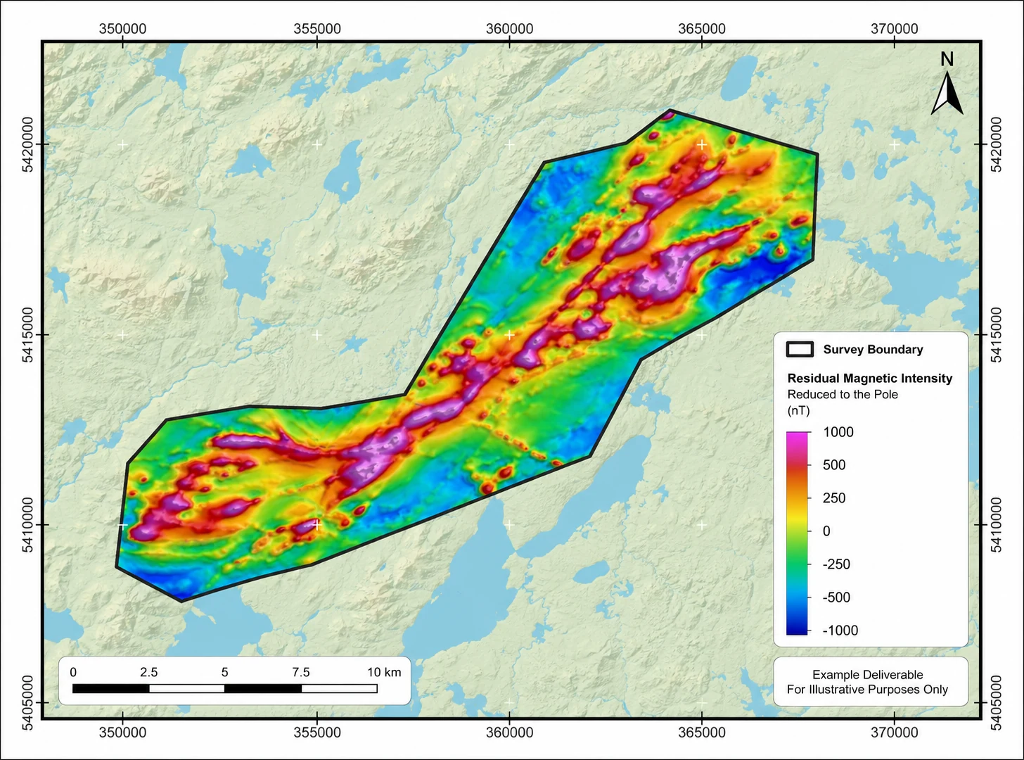
Processing and inversion modelling are completed in-house by our geoscience team using industry-standard software, with standard deliverables provided ready for interpretation. If interpretation is included in the scope, your geologists remain involved throughout the process through regular meetings and updates, with as much collaboration as your team prefers. Final drill-target recommendations are signed by a geoscientist and include clear technical reasoning for each target.

Residual magnetic intensity map reduced to the pole, with survey boundary, north arrow, scale bar and colour legend, from a Rosor drone magnetic survey
Residual magnetic intensity, reduced to the pole. Example deliverable, for illustrative purposes only.

Data quality

How do you know the data is clean?

Because we review the data-quality metrics daily and adjust acquisition while the survey is underway, rather than discovering a problem three weeks later.

How we keep data clean →
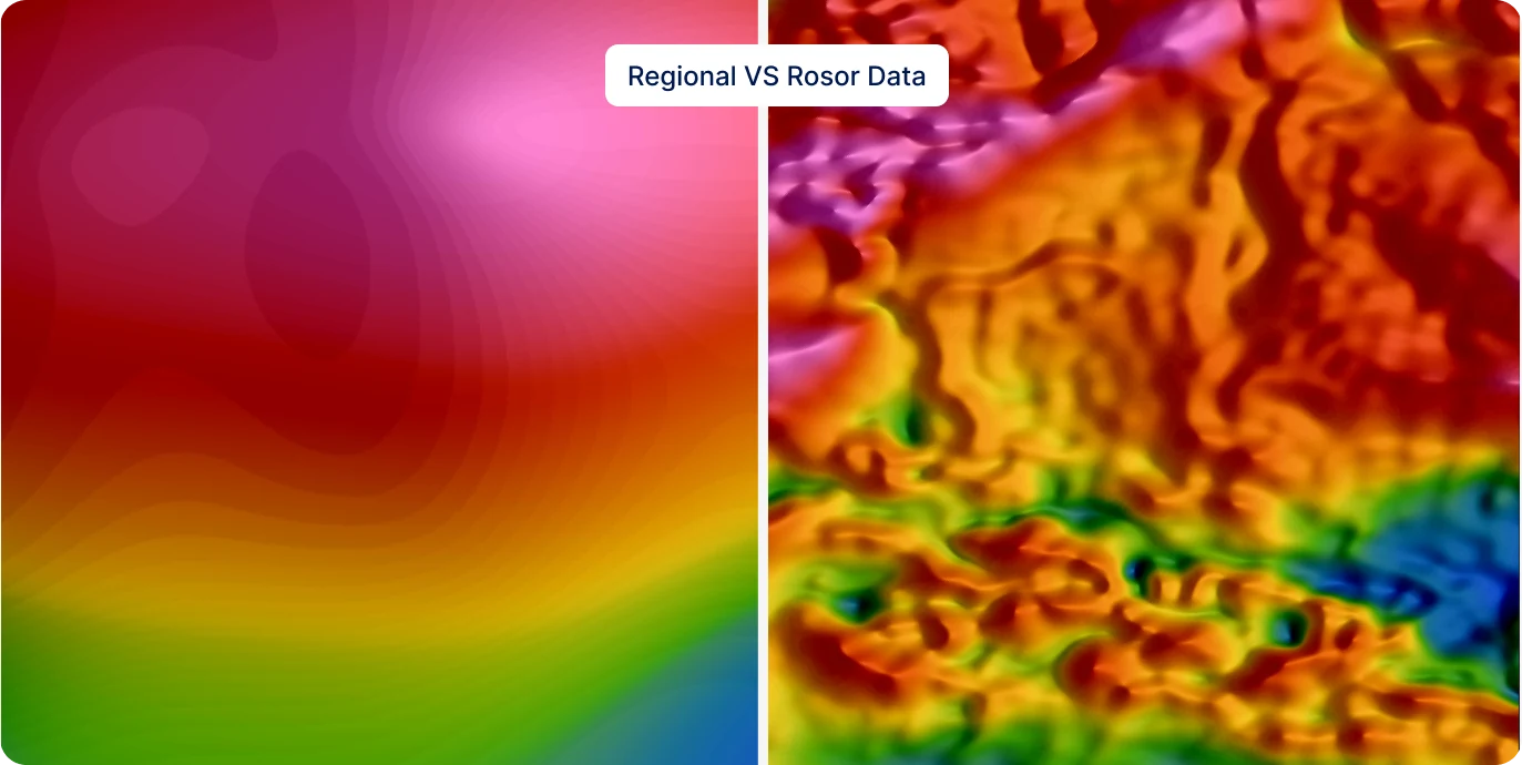
A regional magnetic grid beside a Rosor drone magnetic survey of the same ground, at higher resolution
The same area with magnetic data: regional line spacing vs. Rosor's.

Proof

Programs this approach has served

Completed programs, with the published figures and the clients' own words.

Drone magnetics
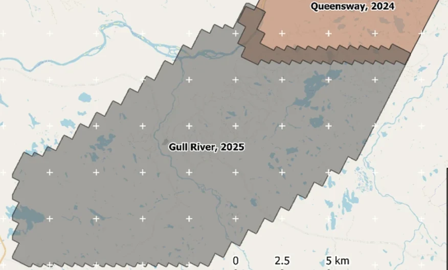
New Found Gold — Gull River survey figure

Gull River

Grand Falls-Windsor, Newfoundland

New Found Gold
315
line-km/day on this program
~4,000
line-km completed

Almost 4,000 line-kilometres acquired across the program, completed on schedule despite delays from a wildfire evacuation interrupting it and geomagnetic storms. Sustained production without trading away data quality.

“The drone magnetic survey provided high-resolution structural insights that significantly improved our understanding of the subsurface geology, allowing us to refine our exploration targets.”

David Drover · Project Geologist

Read the Case Study →
Drone magnetics
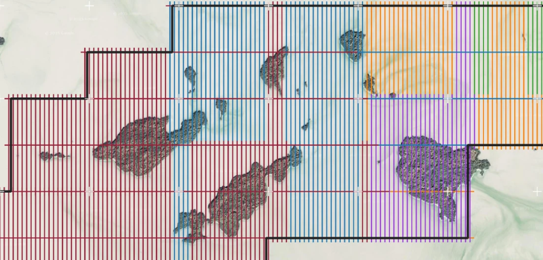
International Explorers & Prospectors — Abitibi Lake survey figure

Abitibi Lake

Abitibi Lake, Ontario, Canada

International Explorers & Prospectors
10
days, site to deliverables
3
days of acquisition

Mobilization to final deliverables in ten days, with acquisition complete in three and no mechanical downtime.

“Throughout the duration of the project, Rosor maintained clear and efficient communication with our team. They demonstrated a strong commitment to meeting deadlines by processing the collected data within a very tight time-frame, ensuring that our exploration schedule remained on track.”

Peter Colbert · CFO

Read the Case Study →

FAQ

Straight answers

01

How is a drone geophysical survey different from conventional airborne?

The drone flies low and tight, with magnetics at 5–100 m terrain clearance, which means strong signal close to source and fine resolution on focused ground. The trade is coverage. On very large regional blocks, conventional airborne still wins on economics.

02

How big an area suits a drone survey?

Focused programs at the drill-targeting stage, from a few km² up to a few hundred. At true regional scale, conventional airborne still takes over on economics and coverage, though that point keeps moving: Rosor has completed programs above 200 km² flying Starlink-enabled BVLOS. Drone surveys earn their keep where resolution and targeting matter more than raw coverage.

03

Can you fly multiple sensors in one program?

Yes. Magnetics, semi-airborne EM (SAEM), radiometrics and LiDAR terrain data are flown on one mobilization and delivered co-registered, as one package your team interprets.

04

How fast is turnaround?

Fast enough to keep a drill program on schedule. An average of 15 business days from completion; larger programs and semi-airborne EM (SAEM) programs are scoped individually. Magnetic acquisition itself is often done in a few days, at up to 500 line-km a day with multi-drone surveys on open ground within reach of roads, and less where terrain or access is harder. A quote comes back typically inside a week of the shapefile.

05

What do you deliver, and in what formats?

Magnetic, radiometric and LiDAR programs ship interpretation-ready: raw data cleaned and levelled, plus map layers and images, in formats that open in Leapfrog, QGIS and ArcGIS (DXF, isosurfaces and geotiffs that go into your existing datasets). Magnetic surveys also include a 3D unconstrained VOXI model, with a constrained model available where you can supply the constraining data. Semi-airborne EM (SAEM) deliverables, including resistivity models, are scoped with the survey. Geophysical interpretation with geological context is scoped at additional cost.

Talk to an expert

Talk to a geophysicist about your program.

Send us your shapefile. We'll come back with a preliminary read, a coverage plan and a budget range.